InfoWorks CS version 7.5
From Wallingford Software press release:
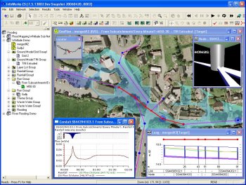
Wallingford Software announces that the next release of its flagship wastewater network management solution, InfoWorks CS v7.5, adds a powerful new capability for those seeking to accurately model overland urban flooding. This new feature, available this summer, produces flood mapping to represent flood depths and area of spread across the detailed local ground model.

Using a ג€flood compartmentג€ to define the boundary of the flood mapping, flood levels within the compartments are calculated at manholes. When there is more than one manhole or flood point within a compartment, the flood levels can be calculated between the flood points.
Overland flow pathways can also be examined, showing the routes by which floodwaters access low points such as gardens and car parks. The flood depth is calculated from the flood level relative to the ground surface as represented by an InfoWorks CS ground model.
The display of results can be in both plan and cross-section images. In the plan view, color coding can represent the flood depths across the area. The cross section view shows both the network below the ground, and the image of the flooding above ground level.
For more information see Wallingford Software web site.
Hello, where I can download this software with licence only for test..
please tell me
thanks
Luis – you should contact Wallingford Software:
http://www.wallingfordsoftware.com/
I want to download this software with licence only for test..
hello
if that possible
i want to download InfoWorks CS for (25 nod)
How can I download InfoWorks for testing?
Please send me free license to use any version of infoworks cs for drainage systems for test purpose.