Network connectivity using GISRed
I have been working for some time now on a new network model for a large city with population of about 280,000. The network layout was received from the municipality in AutoCad format. The main problem with this file is that it was not built with a water distribution model perspective. The file is built from many polylines that intersects with no junctions (nodes) to connect them. In some cases lines that should connect do not. In other cases lines that should not be connected are connected.
Iג€™m using the free ArcView extension for EPANet called GISRed to import the AutoCad file and convert it to an INP EPANet format. GISRed was developed by Hugo Bartolֳn and directed by Professor Fernando Martinez both from the Research Group of Hydraulic Networks and Pressurized Systems (REDHISP) at the Polytechnic University of Valencia (UPV). See GISRed home page.
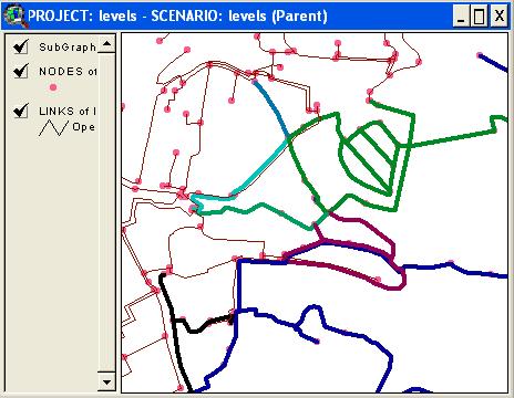
One of my main problems was that after I imported the layout to the INP file I realized that since the poor shape of the AutoCad file my network was disconnected in many places. Going over the entire network, link by link and node by node, is a tedious job. The solution was found once again within GISRed. A tool called ג€˜Connectivityג€™. It does a simple thing. It colors each subset of the network in different color and allows the user to see exactly which parts are disconnected.
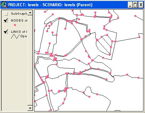
Here is a part of the network:

One can think that the pipes are connected in most places but in order to check this assumption every connection must be examined. After running the connectivity check with GISRed the following picture is presented:

Each subset of the network has a different color so the user can easily see the parts that are disconnected and can easily fix it.
All in all, this great feature had saved me a lot of time. Valencia people: keep up the good work!
The team will be giving a workshop on GISRed v1.0 at CCWI 2005 (Computing and Control in the Water Industry)
Can somw one provide me user manual for GISRed as the designated site for downloading this manual is not funcional.
http://www.redhisp.upv.es/software/gisred/GISRed_eng.htm
Thanks a lot.
Regards
Ken
Kanwar – the site is up and running again.
Thanks for developing this extension, it is fantastic. For me better than DC water design extension but I appreciate all. Chears to REDHISP group and Dorsch Consult team,